Skills Applied
User Research, Strategy, Data & Machine Learning, UX Design, UI Design, Prototyping, Graphic design
Team Members
Independent Study
Duration
15 Weeks
Public transit strives for convenience, but users encounter hurdles like information overload, an inefficient payment system, and inaccurate data, causing frustration and the feeling of lacking control of the situation.
A range of products and systems exist within Google that can help simplify the usage of public transit when integrated into a cohesive ecosystem.
Expanding Google Maps; the most widely-used navigation app, to incorporate existing Google and non-Google products and services in order to create a more seamless and usable experience.
Public transit in the US has declined, with car travel becoming more convenient. This has led to neglected infrastructure and reduced funding. Yet, roughly 10% of Americans, around 30 million people, rely on public transit, along with millions of tourists.
In recent years, alternative transport and Mobility as a Service (MaaS) providers such as Lime, Byrd, and City bike-share have become essential to urban transportation and should be regarded as a component of a metropolitan area's public transport system.

The experience of transit within Google Maps will be seamless. It will be included in an auto-update, eliminating the need for users to put in any extra steps. Users will be introduced to the new features and given the option to go through the set-up process for City Transit.
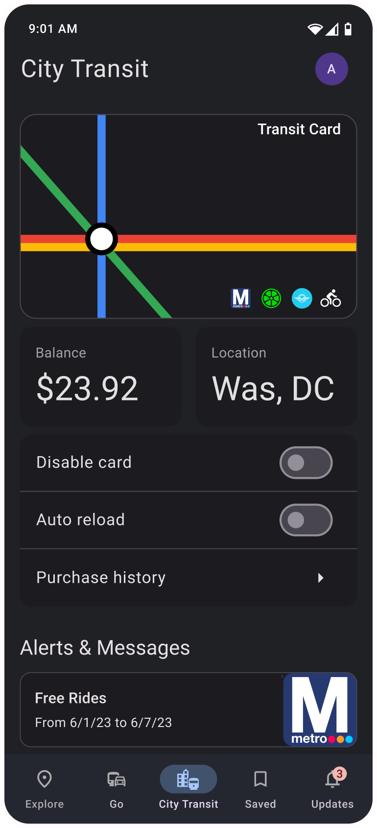
The first update will include 3 major features: Flex Way-finding, Transit Card, and Smart trip engine.


Users will be able to set up their preferred modes of transit, walking preferences and even integrate MaaS accounts.
Going through the initial set up will make the overall experience with transit infinitely better as transit will provide the user with exactly what they need.
At a first glance, Maps will still have a familiar look, however the primary navigation will change in order to make “City Transit” more prominent and easy to access, and the “Contribute” tab will be moved to the FAB menu.


The “City Transit” page is where the user will find and be able to manage their Transit Card. This is also where they can receive communication and alerts from their local transit agency.
SOLVES FOR - The transit card will eliminate the pain point of inefficient payments and allow users to get the most value for their money
If a user has opted into City Transit they will be recommended multimodal routes based on the mode preferences they set.
The route cards will also provide additional information that might impact the mode of transport such as weather, outdoor travel time, vehicle availability , etc.
SOLVES FOR - Inefficient routes and lack of route options. Many times a city might not have a direct way to get from point A to point B, but combining modes can allow users to have more flexibility in their way-finding.


For Bus and Road based recommendations, City Transit will aggregate other traffic data to provide users with the as accurate as possible delays.
SOLVES FOR: Anxiety induced from the lack of information and the feeling of lacking control.
Expanding the Route cards for additional information will provide users will more Information about all the different modes they will use and also allow them to easily add them to their Transit card for payment purposes.


Transit Partner Program
Many public transit agencies around the world already have an established relationship with Google Maps and provide data to google through General Transit Feed Specification (GTFS) system.

Mobility services partners
Urban MaaS providers such as Lime, Bird, Lyft, and City Bike Shares utilize Google Maps infrastructure to operate their apps and provide vehicle location data.

Digital Ecosystem
Creating an ecosystem of apps users are already familiar with will make opting into the system much easier and convenient.

Mo' data, Mo' Models
GTFS Data + MaaS data + Roadways data
can help build a powerful machine learning model unique to City Transit. This will allow Transit to provide users with all the information they might night to feel in control of their situation.
I conducted this independent study in three phases:
During the Discovery phase, I gathered data on end-user pain points, conducted interviews, and performed secondary research on the market landscape and competition to validate my hypothesis.
In the Ideation phase, I started generating ideas for potential solutions and continued to conduct research on the feasibility of said solutions.
Once I arrived at a feasible solution, I began my iterative design process from creating user flows to developing hi-fidelity prototypes.